Overview
This exercise contrasts the three most common forms of thresholding DoDs: i) Simple minimum level of detection, ii) propagated errors, and iii) probabilistic. We use the GCD Add-In to facilitate the analysis.
Data and Materials for Exercises
Datasets
- Wheaton JM. 2008. Uncertainty in Morphological Sediment Budgeting of Rivers. Unpublished PhD Thesis, University of Southampton, Southampton, 412 pp. - *See Chapter 4 & Appendix D*

River Feshie, Scotland, UK
- 700m braided gravel bed river in the Scottish Cairngorm mountains.
- 5 annual surveys
- Mix of RTKGPS and Total Station
- 1m cell resolution
- Download
Prerequisite for this Exercise
I_Thresholding.zip File of Data for this Exercise. Data from:
- Some ArcGIS experience
- ArcGIS 10.X w/ Spatial Analyst Extension
- GCD Add-In
Overview of Thresholding
GCD Provides three primary ways for you to threshold data (all using exclusion):
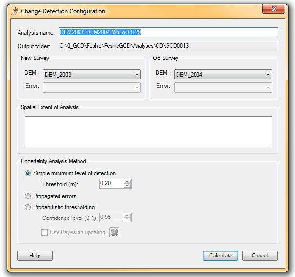
Simple Minimum Level of Detection
In this video tutorial we explain how to use the GCD Change Detection panel to to a basic DoD Analysis with simple minimum level of detection thresholding. This is the equivalent of the raster calculator operation in the 03. Simple DoD in Raster Calculator tutorial.
Propagated Errors
In this video tutorial we explain how to use the GCD Change Detection panel to to a DoD Analysis with propagated errors (from error rasters in the Survey Library) to establish the level of detection threshold.
Probability
In this video tutorial we explain how to use the GCD Change Detection panel to to a DoD Analysis with probabilistic thresholding based on a confidence interval.
This tutorial corresponds with topic G. Thresholding Alternatives in the GCD Workshop. See the lecture materials there for more background on the underlying theories for these methods.
Extra:
How to Make your own Elevation Change Distribtuions
Step by Step
Part 1 - Simple minLoD
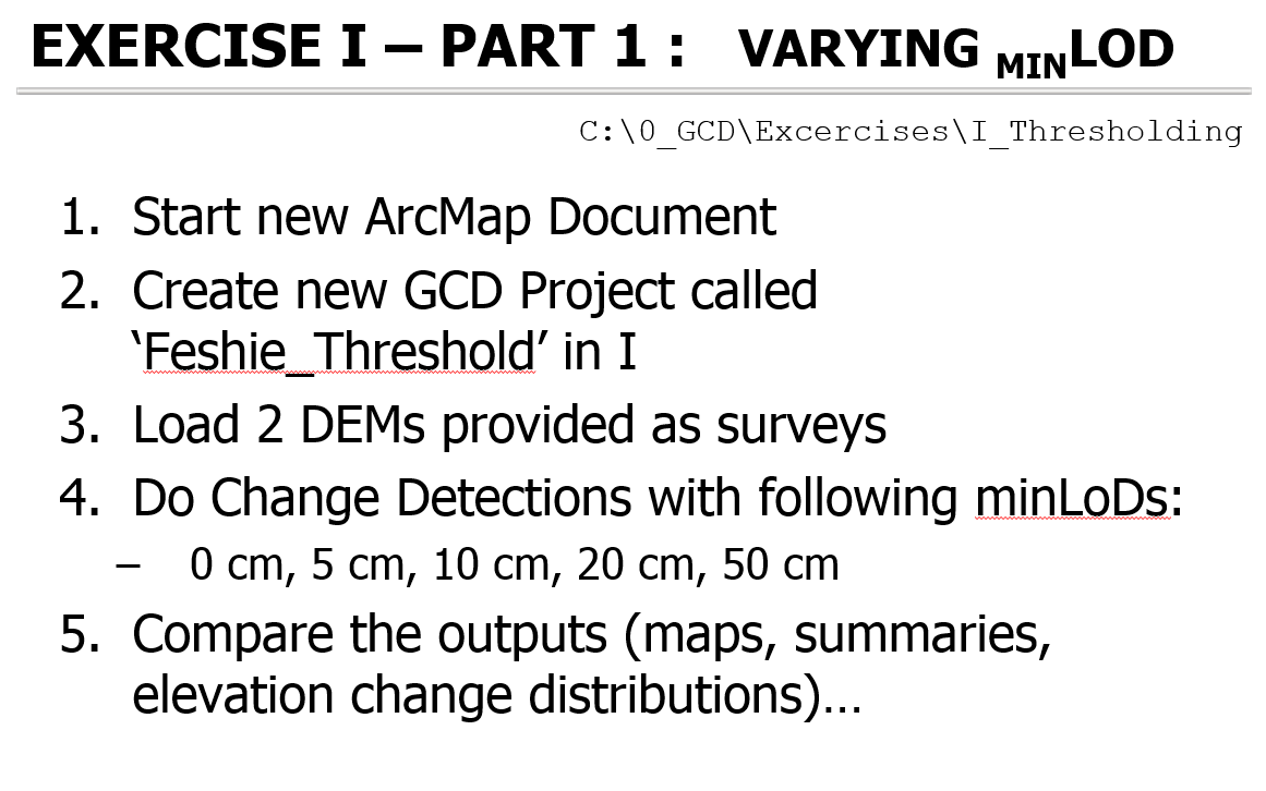 How to do in GCD 7:
How to do in GCD 6:
Part 2 - Propagated Error
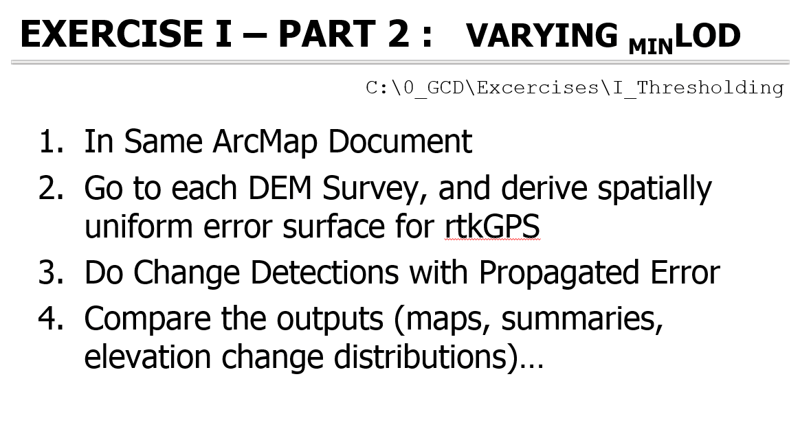
How to do in GCD 7:
How to do in GCD 6:
Part 3 - Probabilistic
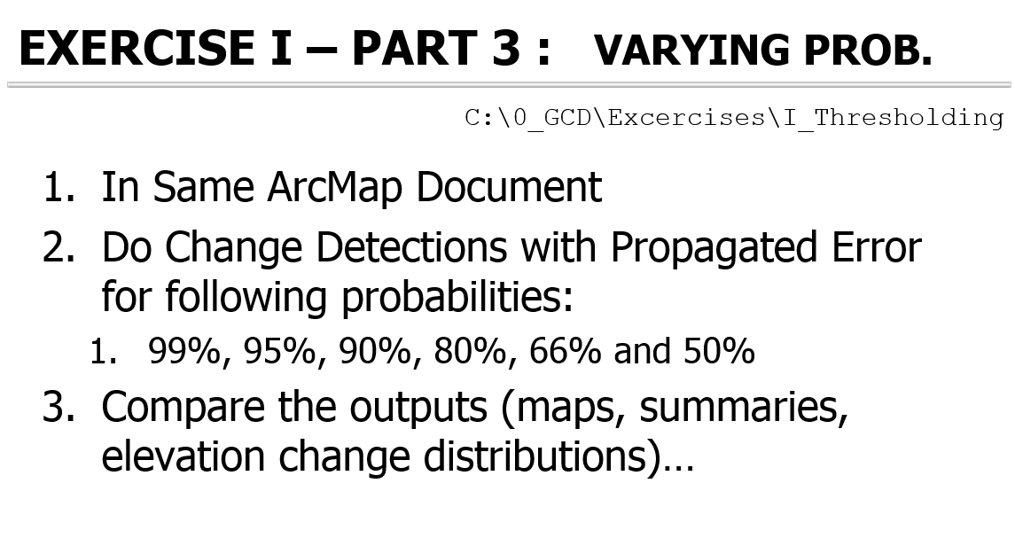 How to do in GCD 7:
How to do in GCD 6: